Saturday, July 4, 2015

A Hike Into Alaskan History

Did you ever wish you could wipe the slate clean and start all over again? Probably everyone has felt like that once when something wasn't going just right. This was not one of those days however, and yet, it happened. I had hit the "Publish" button to upload our latest story and something went wrong. Just like that, the entire blog entry was gone and my slate was wiped completely clean. I'm not sure why Google's auto-save hadn't been saving, but apparently it wasn't. I found myself staring at a blank screen. I said bad words! Seems there's always a lesson to be learned and mine is to always save what I'm working on as I go along...even if the little icon has been telling me all along it's been doing it for me. So, as I write this today I'll be recreating for you as best as possible what was written before. With any luck I'll do it right this time.

The Alaska Railroad has a rich history here in the state. Long before roads linked more remote communities and villages together, trains were the mode of transportation that brought people and supplies where they needed to go. In the early 1900's the Alaska Railroad had a rail spur that ran along the Matanuska River from Matanuska Junction (which would later be colonized to become the town of Palmer in 1935). The train traveled north to the mining community of Chickaloon. It serviced the Chickaloon Coal Mine, as well as the Eska and Jonesville mines. Coal from the Chickaloon mine was used for the Naval reserve.The trains carried passengers, and supplied coal to the military bases near the tent city of Anchorage. The Navy used the coal to resupply ships on their way across the Pacific. It didn't take long for the Navy to realize this was not profitable and they started ship to ship refueling and mining in the area declined. The railroad spur was abandoned in the late 1930's. Sometime later the tracks were washed out north of Moose Creek, which the train crossed on the way to its destination. Chickaloon remains a community of around 275 residents today.

Fast forward about 85 years and the rail bed that once carried the train is now called The Palmer-Moose Creek Railroad Trail. It's a wonderful, unmotorized trail used by hikers and mountain bikers. We caught the trail in Palmer and headed north. Some of the old rails were still visible at the beginning of the trail. Rockslides and years of erosion must have washed most of them away, but it gave us a sense of being on the tracks and actually retracing the route the mighty train once traveled.


Birch, Cottonwood and Alders have grown up since the days of the train and a lot of the trail now passes through thick woods. It was a hot day and we were grateful for the shade. Every so often though, we'd break out into the open to glimpses of the Matanuska River below us. The river must be more than a mile across at this clearing, with the Chugach mountains jutting up on the other side.


Not too far out of Palmer we came to a rockslide that had washed a huge portion of the mountainside away. We had to be really careful walking over that section so not to lose our footing. People biking the trail would have had to stop and carry their bikes across. I wouldn't have wanted to be out there in the rain or in icy conditions. One misplaced footstep could have been disastrous.


Retracing this route gave us a sense of what it would have been like to ride that train long ago. As we continued farther north we noticed a large brown structure over the bank. As we got closer and walked down to it, we realized it was the rusted remains of a passenger car that had derailed years ago and tumbled down the mountainside, settling on it's side. How many people lost there lives that day? Later, on our return we saw another train car at the base of the mountain along the banks of the river, partially submerged in the water. What happened that ill fated day to cause the train to end up there, we'll never know. I'm sure there wouldn't have been a way to remove those cars. Instead they'll forever remain where they came to rest, as rusted pieces of Alaskan history.


The brown you see is the train car partially submerged in the river.

The terrain was mostly easy and level, although the elevation changed. Sometimes the trail took us quite high on the steep slopes and other times we were fairly low on the mountainside. We kept thinking the trail would take us to the river's edge, and maybe it would have if we'd hiked the entire trail. Finally we decided to climb down the bank and try to get to the river. Over the centuries the Matanuska River has changed course many times. It's a glacial fed river and as the glacier receded the rocky moraine is what remains. What we realized once on the riverbed, was that the actual flowing braid of the river was much farther away than we were willing to walk in the hot sun.

This is the old riverbed.....

The flowing river is close to the mountain in the background....

We don't consider Maggie much of a water dog, but when she found this snowmelt she made it perfectly clear she was not going any farther and she'd had enough hiking for awhile! After letting her rest and cool off we began our return to Palmer.


Hiking back was just as pretty and we got to see it all in reverse. This time we passed a few people on the trail. We got a few more pictures of the Matanuska River and the Chugach range.


If you look closely you can see a hanging glacier in the center of this one.....

Who'd have thought that within minutes of leaving town we'd be transported to a bygone era that day. Our simple day hike opened up a portal into the lives of those adventurous pioneers who settled there years before. They must have felt like they were a million miles from anywhere a hundred years ago. We're reminded how tough they had to be to survive in that harsh environment. We think of the men working in those coal mines and of the unfortunate ones who's lives were lost along with the rusted rail cars that derailed from those tracks. What happened that day? Were their families onboard? And we pay tribute to those that built the railroad all those years ago, over rugged land that was anything but kind.

I'd like to think the people that traveled on the rail spur 100 years ago were not much different than Alaskans of today. The pioneer spirit lives on in those who choose to keep it alive. If we let our minds wander we can almost hear the whistle of the train and the conductor yelling "All Aboard! The train is departing!" If we close our eyes, we can picture that train, chugging along on those rusty old rails. All we have to do is imagine, and keep an open mind.

Wednesday, May 13, 2015

Camping With Bison


We’ve made the trek between Alaska and the Lower 48 many times throughout the years, in every season except spring, until now. For this particular trip we’ve really slowed the pace and are taking time to stop and explore. There’s a lot to see along the way. As the landscape sheds it’s last blanket of winter, it’s waking up and coming alive once again. Spring is beginning to peek through.


A hint of green in the trees and grass

It had been 17 years since the last time we’d stopped for the night at Liard Hot Springs. It’s a popular place for travelers to stop, with a beautiful picnic area, playground and great campground. The original boardwalk to the hot springs was put in while the highway was being built in 1942. Imagine walking through the tundra all those years ago and coming across a stream of 102-106 degree water flowing through the forest! These days it’s the reward for travelers to relax after the day of driving. The hot springs are a good ¼ mile walk, on a beautiful boardwalk over wetlands and boreal forest. We were looking forward to taking a dip in those soothing waters once again.

We’d just finished setting up camp, took Maggie for a walk and were about ready to hike to the hot springs when we realized a bull wood bison was in the campsite just across the road from ours. Duane grabbed the camera and walked back to take a look. There he was, a huge bull, munching away, not really caring who was around. Soon enough he meandered back into the woods. 

The next day as we were leaving the campground, we had to stop for another bull blocking the road. It was cool seeing the massive animals up close and gave us a new experience. Not everyone can say they’ve camped with the bison. The hot springs were pretty awesome too.

This is the big guy blocking the road. Best to let him have his way


Wood bison were introduced into this area many years ago. We usually see some along the highway. Last year we saw groups of them for at least a one hundred mile stretch of highway. This time we didn’t see nearly as many. I suppose with the early spring and plenty of feed in the woods they don't have to hang out along the roadway. However, we did see several small groups of bison and got to photograph this big guy enjoying the sunshine.

With spring emerging, so are the bears. We’ve been excited to see many black bears and several grizzlies. We’ve also seen an abundance of elk, Dahl sheep, some caribou, stone sheep, moose and a gorgeous red fox, which decided to pose for me to take his picture. Thank you Mister Handsome!
 Grizzly & cub
Young Black Bear

We stopped along the way and hiked into Rancheria Falls. There were still some snowy patches on the ground, even though it was warm and no longer freezing at night. It wasn’t a very long hike, but well worth taking the time to do it. We walked for most of the way on another wonderful boardwalk, with big decks overlooking the falls.

Rancheria Falls
Nice place to hike on Mothers Day

Maggie has stayed incredibly busy the last few days keeping watch of our camp and making sure squirrels don’t get too close. It must be instinct for them to pester dogs because they arrive as soon as we do and start squawking at her. We can rest assured Maggie’s on guard. She’s been going to bed exhausted and in the mornings can hardly wait to get back outside again. She takes her job seriously!


Our journey continues. We’ve found awesome places to park each night, enveloped in this natural wonderland. We sit  around a roaring campfire, enjoying each other’s company, sharing a glass of fine, boxed wine, reminiscing about what a great day we’ve just had. Life doesn’t get much sweeter than this. 

 Big Creek Campground, Yukon Territory

Pine Lake, outside Haines Junction where we camped one night

Buffalo Jump, Big Beaver & Best Buns In The Galactic Cluster


Now that should get someone’s attention!

We’ve left the U.S. and are driving through the country of our best friends to the north, Canada.  After spending about 10 days in Northern Idaho, visiting Duane’s mom and camping on our friends’ Ted & Donna’s property, getting some much needed work done on the fifth wheel, Maggie having surgery to remove a thorn in her foot, and having fantastic visits with all our good friends in the area, we hit the road to travel to Alaska. Internet is sparse to none, and expensive at that, so this post won’t be published until we reach civilization once again.

Here's Maggie sporting her pretty pink booty after surgery

I said in a previous post that it’s the journey, not the destination that matters, but when we were looking at our trusty “Milepost Magazine” we found a historic site we were drawn to. Head-Smashed-In Buffalo Jump, in southern Alberta. Just for the name itself, we had to go.  It didn’t seem too far out of our way, maybe 30-40 miles at the most. This time it was all about the destination. We were only a few miles off the main highway when the road to Head-Smashed-In turned to gravel. 
Dust billowed up behind us for what we found out was 37 kilometers until just before reaching the site of the buffalo jump it turned back to a paved road once again. What we later found out is if we had taken the road from the opposite direction, which was about the same distance, we would have avoided the gravel altogether. However, it was beautiful, high plains country that we wouldn’t have seen if we changed routes.
Those cliffs the actually jump site. Years of erosion have worn it down. It use to be a 1,000ft drop.
Head-Smashed-In Buffalo Jump is the most well preserved, largest known archeological site in the world where Indians, for what is estimated 6,000 years, stampeded buffalo over the cliffs, to their death. Today it is a World Heritage Site. There is a beautiful state of the art interpretive center. Some of the First Nation People working there are decedents of the very Indians who took part in the hunts. They show a film, reenacting what a hunt would have been like. The preparations were well thought out and everything had to be just right. The People created long lanes, using piled up rocks and branches sticking up to look like trees on the high plains. Through studying their behavior, the Indians learned the buffalo would see the stones and trees as solid barriers and not try to break thru them, thus running through the created pathway.  After rubbing buffalo scent on a “chosen” warrior from the tribe, wearing buffalo skins over his head and body would work his way into the herd. Several others wore wolf skins over their bodies and tracked the buffalo from the edges of the heard. The ‘chosen’ young man would make his way to the front of the herd. Timing was precise. This lead warrior would walk ahead and make the sound of a wounded calf. Once the herd was all making their way to investigate the ‘wounded calf’, the other tribesmen would start running behind them and the ‘wolves’ along side. This would eventually get the buffalo into a complete frenzy and they would start moving. Other tribesmen, women and children who had been hiding along the lanes would stand up and wave robes and blankets as shields, causing even more of an uprising of the buffalo. The warriors would run, the buffalo would run, leading the unsuspecting buffalo to the cliff, and ultimately to their death below. The young warrior chosen for the job of honor, to act as the wounded buffalo, would run fast and then veer off the path just before reaching the cliff himself. The Indians would then give thanks to their Creator for a successful hunt. Nothing was wasted.  They’d process the enormous animals and the village could live for months off their good fortune. It all sounds quite gruesome, yet the planning and ingenuity the People possessed was astounding. The archeological findings there show the bones to go down as far as 10 meters into the ground, dating back thousands of years and as recent as the 1800’s.

The name, Head-Smashed-In was given because history tells of a young boy who wanted to watch the buffalo fall off the cliff from what he thought was a great vantage point, at the base of the cliff back up against the mountain. As the buffalo fell and started piling up, there were so many that the boy was crushed between the dead animals and the cliff. When the tribe finally dug him out, his head was smashed in and so the name came to be.

It seems most towns have some claim to fame. We’ve gone out of our way to see with our very own eyes attractions like The World’s Tallest Wind Chime, The World’s Largest Jackalope, The World’s Largest Truck, etc. Beaverlodge, Alberta wanted a draw to their small town, so they erected The World’s Largest Beaver in the town’s cultural center. The beaver is very symbolic to the Canadian People. At least that’s what the sign says. This 15 foot tall beaver, perched on a 19 foot log is hard to miss. We could see it for blocks as we drove into town. There’s a huge parking lot where visitors that choose to, can stop, stretch their legs and admire the extremely large mammal. I guess our names can be added to that list. We’re suckers for roadside attractions.
Had to stop for the World's Largest Truck too!

Our drive north until now has been a lot of fun. So far, we’ve seen bighorn sheep, coyotes, one scrawny moose and a black bear, which could have cared less about us trying to get a picture of it. Even though we’ve driven The Alaskan Highway many times, this trip is a slower pace, stopping to see those things we’ve never stopped for before. We’re enjoying the journey. It really is wild, beautiful country that few people will ever see.  We’ve visited with folks at rest stops along the way.  There always seems to be camaraderie among those making the long drive between Alaska and The Lower 48. People are generally interested in finding out your story, where you’re heading and where you’ve been. Just today Duane talked to exchange students from Germany, met Peter, a man on holiday with his wife from Germany, and people from various towns in the U.S.  We became friends with Pam and Warrick from Australia and saw them in several towns along the highway. We even met folks from our hometown of Willow, Alaska! It really is a small world, isn’t it?

Our stop for tonight is a lodge/RV park in Interior BC, on the Tetsa River. The woman running the place is a very friendly, yet a no nonsense kind of gal, with a sign above the desk that reads “No Sniveling”.  “No Sniveling” is also on their gas pump outside, where unleaded fuel is sold for $1.75 per liter. 
Their signs, which we’ve been seeing for miles, claim The Best Cinnamon Buns In The Galactic Cluster. How could we pass up something as out of this world as that? However, their ad also says they have electricity, but they asked us not to use too much or it will overload their system, plus they shut it down at 10pm anyway. They advertise WiFi, but warned us not to download anything or it will kick them offline. They offer showers but have no hot water. And they asked us to park sharing a space with another big fifth wheel because it’s the only site with a water line that’s hooked up.  It remains to be seen just how cosmic the cinnamon buns actually turn out to be.  
 Our campsite for the night
Tetsa Lodge
This lodge is typical of what we find in the Far North. Amazing pioneers, working with what is available to them in this harsh land, providing services to weary travelers who make their way along this long road. Many of these lodges, like Tetsa River Lodge, have been here since the Alaska Highway was being built during WWII. Tetsa Lodge is run by a third generation family and it’s the life they know and love. Fuel is trucked in from hundreds of miles away and in some cases lodges are run by generator power only. Wood stoves still warm the insides. In a lot of ways, not much has changes except the road itself. The real pioneers are those who came before us, who battled their way over basically a muddy trail all those years ago to settle in this wilderness. We simply follow in their steps.

So goes our migration to Alaska. Good times, fascinating people, interesting wildlife, and as always, a great adventure.
 Muncho Lake area
 Caribou, caring less that the camper is passing 
 Grizzly Bear 
Black Bear
Stone Sheep


Tuesday, April 21, 2015

Crashing Waves, Giant Trees & One Happy Dog

Wow! The power and grandeur of the Pacific Ocean! I don't think there's anything like it that compares. I can remember as a child, crying when our weekend was over and it was time to go home. I had so much fun at the beach that I never wanted to leave.

Last week we left Chico, CA and made our way across a winding Hwy 299 to the ocean. Both Duane & I were excited to be back on the Pacific Coast. Our first evening there, we checked out Trinidad Beach and hiked a really cool trail up, over and around a big hill. From there we were able to overlook the town, the bay and the beach below the cliffs. We got our first taste of that clean ocean air and Maggie got her feet wet in the surf for the first time ever. I think she loved it from then on. 


Not knowing what kind of accommodations would be available or how crowded the parks would be, we called ahead and booked the Azalea Glen RV Park, in Trinidad. It ended up being a charming little park, nestled in the lush trees and beautiful Azalea & Rhododendrons that grow at least 20 feet tall. The owners had planted rows of hedges between each RV site, creating nice privacy. They had built the cutest fenced in dog area and there was a pretty pond on the property, full of frogs that made their presence known each night. 


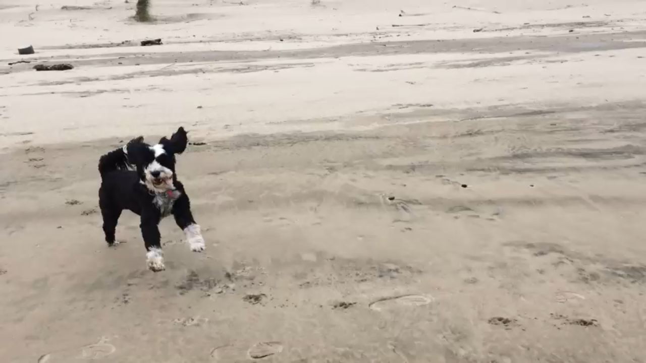
On Saturday, we did a lot of driving around, checking out Eureka (where Duane was born), Arcata and Fortuna, where we had a great visit with Duane's Aunt Glo. We discovered a beautiful beach on the little island of Samoa. It didn't look like very many locals used it and we could see for miles in either direction. We let Maggie run, and run she did! She thoroughly enjoyed chasing birds and getting them to fly, then run again while they chased her. She was free! She ran to play with a couple of dogs that were fetching rocks in the water. She was so happy playing, then took off chasing birds again! It was really fun watching her be so happy! 

The next day we started making our way north up Hwy 101. The weather was fabulous! We'd been able to keep the coats put away and actually spent the day in short sleeves. There are so many gorgeous places to stop that overlooked the shoreline. 


Everywhere, there was beauty! There's almost a tropical feel here because of the moist air and thick foliage. We stopped several times to hike in the Redwoods and take scenic side roads. Even though both of us have seen them many times before, we were still in awe and blown away by how gigantic these ancient trees are, and how small they made us feel. I commented that if it had been 37 years since we were there, those trees have 37 more rings than the last time we saw them. 


We stopped at a state park in Brookings, Oregon and hiked the trail down to where the water was crashing onto the shore. Every twist and turn of the trail gave us sneak peaks until we reached the bottom and could just stand and admire the view. The water was such a brilliant blue, the waves intense.


(This rock is about 30 feet tall and reminded me of a bird)

Our plan was to spend the night along the Sixes River in a BLM campground we'd heard about on a blog we follow. The directions were great and we found the road off Hwy 101 without an issue. However, as soon as we made the turn onto the road we saw a sign for the campground, with a CLOSED sign hanging below it. We already knew from the blog this was a narrow and winding road for four miles to the campground. With our big rig there was nowhere to turn around, leaving us no choice but to drive all the way to the campground before finding a wide spot to turn around. We found the campground to be a beautiful grassy spot along the river that would have been perfect, if only the gate wasn't locked! 

Since we've gotten pretty good at altering our plans (jello, you know) we quickly rerouted back a few miles to Cape Blanco State Park. The wind was blowing quite hard by then and Duane got out at one campsite, just to quickly get back into the truck and look for another place more protected. The site we chose was beautiful,  tucked deep in the woods, with a trail to the bluff overlooking the coast just behind our camp. We were home! The next morning we thought we'd visit the Cape Blanco Lighthouse before leaving the park. When we drove out to the bluff that looked out on the lighthouse it was completely socked in with fog and the wind was whipping. The lighthouse came in and out of view as the wet mist billowed in. The road looked too narrow for us. Not knowing if there would be adequate room for us to turn around once we got there, we decided not to make the drive. We also chose not to walk it either in the blowing, misty fog. We said goodbye to Cape Blanco and continued north. Happy to have seen it from afar the evening before.


We only drove about 140 miles the next day, finding ourselves in Newport, Oregon in the late afternoon. Since we'd had such good success with the state park the night before we decided to try another. We pulled into South Beach State Park and immediately found a wonderful spot to settle in. This park was even nicer than the last one! We had great neighbors on either side of us. Maggie approved of their dogs so life was good! There were wonderful trails and we headed out to the beach. Maggie again got in a terrific run and must have checked out most of the jellyfish that had washed ashore. She ran and ran, jumping and playing like a puppy. Even though the wind was blowing hard we totally enjoyed our walk and Maggie's run.

Today the weather has settled in and we've decided we'll probably head inland. We walked out to the beach one more time this morning and saw the Yaquina Lighthouse across the water. Again the fog was rolling in and out and as we walked back to our camp it became heavy enough to almost be considered rain. We visited the lighthouse just north of Newport on our way out of town. The lighthouse might be beautiful, but the heavy mist and wind by this point had made it much less enjoyable to walk around outside. It was hard to get photos with our heads pointed down to keep the wind and water out of our faces! The interpretive center was really nice though and I bought a cool shirt.


We're in Tillamook, Oregon tonight. We watched cheese being made and packaged, ate our share of samples and delighted in a huge bowl of ice cream at the Tillamook Cheese Factory. I had been there before, many years ago and Duane had never been there. It's really interesting seeing how a product we see in the stores is produced. 

This brings us to the present time. We're parked right beside a giant old cargo plane, outside the Tillamook Air Museum. The wind is still blowing hard and every once in awhile the trailer rocks from the big gusts. This is home for the night. We want to tour the museum in the morning before leaving town and leaving the ocean to head inland.


Both of us want to come back soon and spend more time on the Pacific Coast. It's a place we can't seem to get enough of.  Just like when I was a little girl, I'll leave a small portion of my heart behind, until we return again. This time it won't be me that cries when it's time to leave. However, I think Maggie might.