Friday, July 31, 2015

Haulin Ourselves Up Alaska's Haul Road

Recently we took advantage of a few free days and checked another road trip off our bucket list. We drove the Dalton Highway. Our plan was never to drive the entire 416 miles of the Haul Road, all the way to Deadhorse. Instead our original goal was just to get above the Arctic Circle. Duane had been there once, but Jean and Maggie never had. With no prior planning, we threw a few things into the truck and late in the afternoon we headed north. We rolled into Fairbanks around 9pm and found a cheap motel for the night (not easy to do in the summer). It's not often we take off without any kind of a plan, but it certainly made for more of an adventurous outing. We hit up the grocery store on our way out of town the next day, bought items to make sandwiches and some snacks and figured we'd wing it from there on out. 

75 miles out of Fairbanks we intersected the Dalton Highway. 


 Guess you only need one sign when the maximum speed limit never changes...

The Dalton was the 11th and most recent highway built in Alaska

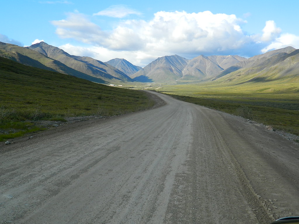
When oil was discovered in Prudhoe Bay in the late 60's, they needed a way to get it to market. The U.S. was right in the middle of a gas/oil crisis, so building a pipeline became the nation's priority.  The 800 mile Trans-Alaska Pipeline was built in three years and the Haul Road was built in record time, just five months! It's only been since 1994 that the general public's been allowed to drive the road it's entire length. Now it's kind of a destination highway, meaning the road itself is the attraction, not how far you actually travel on it. 

Having been made famous by the show Ice Road Truckers, we were surprised, and happy that we didn't encounter a lot more truck traffic than we did. However, we were stopped quite awhile waiting for this big rig to pass by.....
The truck & trailer rig was 105 feet long and it's cargo about 20 feet wide. The three big trucks traveling behind it are pusher trucks to help it get up the hills. Duane talked to the flagger who told him it has a permit for maximum 25 MPH. That's a slow 850 mile trip from Anchorage to the North Slope! 


We were told at the visitor center that Alyeska Pipeline would be starting spill response exercises the next day and be sure to check out the airboats they'd be using. One is the largest one in the world. I'm sure you can tell which one! 


The Yukon River is humongous! 


Here's a section of the pipeline just before it crosses the Yukon River

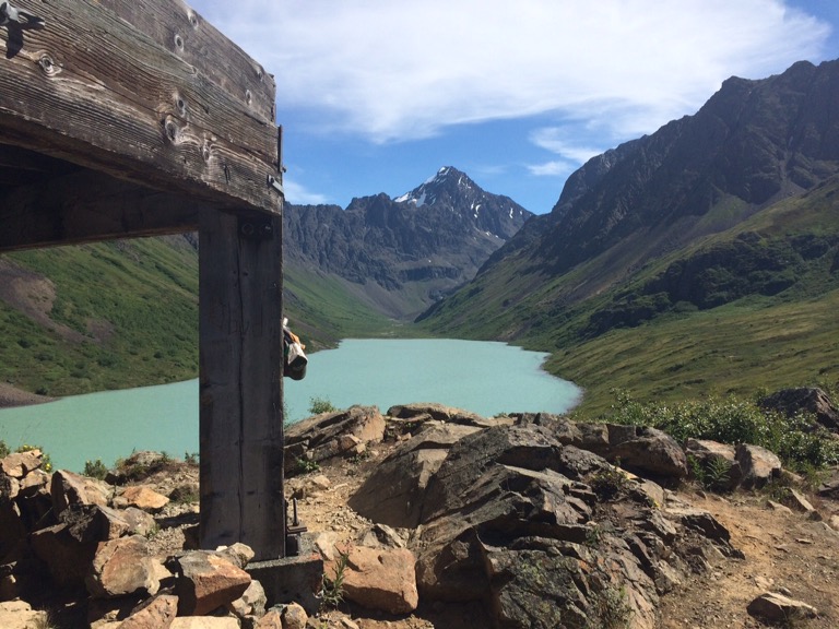
The pipeline parallels the road, either above or below ground for the entire length of the road. It's the backdrop for a lot of the beautiful scenery and sometimes the star of the show. Our vantage point at the top of this particular hill provided us this interesting view.

The next stop on our travels was Finger Mountain. The panoramic views from this alpine tundra are magnificent. Granite slabs, called Tors jutting up across the landscape were created millions of years ago, when magma pushed up through the bedrock. It became hard granite as the magma cooled. Throughout time, erosion has washed away much of the smaller and softer rocks. These granite tors are what remain today. Maggie led the way to the most prominent tor in the area, Finger Rock.


Look close. Can you see Jean in the center of the tor?


Even though fireweed grows prolifically in the area, its unusual to see white fireweed...


Before long we reached the Arctic Circle. At this imaginary line that circles the globe the sun doesn't set for 24 hours on the summer solstice. From here north, the time the sun stays above the horizon gets progressively longer. This is great for accomplishing all your outdoor projects. However the opposite happens at winter solstice, when the sun never makes an appearance for one full day! At the spring and fall equinox there is exactly 12 hours of daylight at the Arctic Circle. Everyone driving the Dalton stops here to mark this special time in their lives with a photo. It's easy to find someone to take your picture. Unfortunately there were a couple of dogs running around and Maggie was being an idiot in the truck and wasn't allowed to get her picture taken with us.


We got a certificate to prove we crossed it.... cool huh?
We'd arrived at our target location. However, the weather was fabulous, the lack of mosquitoes was mind boggling and we were seeing too much incredible country to turn back now. We decided to continue on. 75 miles farther north as we crossed the middle fork of the Koyokuk River, we took a turnoff to the historic village of Wiseman. It was a bustling place when gold was discovered there in 1907, but now is a pretty sleepy little hamlet. We had thought of finding a cabin or B&B to rent for the night, but I guess they close up shop early in the evening. We drove around, and hardly saw a soul. Sort of feels like stepping back in time 100 years.


Fireweed lines the shore of the Koyokuk River...

Not far out of Wiseman we spotted this very skinny moose in a pond near the pipeline. She didn't seem at all concerned that we stopped to watch her eat. Gotta say, Maggie was the one to spot her. Duane was just taking a picture of another mountain!

Being in the land of the midnight sun allowed us to continue driving late into the evening and the lighting was beautiful. Large fireweed patches were breathtaking along the northern mountainsides, especially when the sun hit it. From our vantage point where we took this next picture, we watched the sunshine light up the land as the clouds were quickly moving overhead. It looked like someone was playing with a flashlight.


Before long, Sukakpak Mountain came into view. They say when the sun hits it just right, it glows. It sort of seems like a glowing rhinoceros trying to hide behind the the mountain in the foreground. 
As we got closer the rhinoceros came out of hiding....

There were so many incredible sites to see along this journey and we were delighted we'd decided to continue on instead of turning back at Arctic Circle. Our new turn-around point on the highway would be the north side of Atigun Pass. After passing Sukakpak Mountain, the landscape began changing as we approached the Brooks Range. We had reached Atigun Pass and at this point we crossed the Continental Divide. Rivers north of here flow into the Bering Sea and rivers flowing south, flow into the Pacific Ocean. Atigun Pass was made famous by watching the Ice Road Truckers make their way through that pass in horrific conditions. Although we weren't in ice or snow, it didn't take much imagination to realize the expertise and experience the truckers need to make it safely through this section of the highway. 


This was our view coming back over...


While driving toward Atigun Pass we kept our eyes open for a place we could spend the night. We couldn't have been happier than this sweet boondocking site along the Dietrich River, at the base of our now favorite rhinoceros, Sukakpak Mountain. The mountain looked totally different looking at it from this direction.

Even late at night the mountain across the river from us was in full sun. The sun eventually set at 12:33 in the morning (I had to look that up online) and rose again around 3:00am. However, the sky was quite light all night long and sometime about 2am when I looked, the pink clouds were still illuminated.

Had we known what great weather we were going to have and had brought more food along, we would have been tempted to stay along that river for another day. Reluctantly, we left the next morning to head south. We'd spent a night above the Arctic Circle and experienced a unique area of Alaska not visited by many people. We couldn't resist stopping again at Arctic Circle so Maggie could have her picture taken too. We're pretty certain she was happy about that. 


Friday, July 17, 2015

Back Valley And The South Fork Trail

January 1981. Having moved here from California right at Christmas time, we were just beginning our life in Alaska. Friends of ours, Richard & Becky invited us to their house for dinner. We didn't know them very well. They were the only couple we had made contact with in Alaska at the time. Duane had gone to school with Becky in the '70's so we had a connection. They lived way up on a mountain road in Eagle River, Hiland Road. It was a very stormy night with a chinook wind blowing and ice rain falling. Knowing we couldn't make it up there in our old pickup & camper, we parked at the bottom of the road and they came down the mountain to get us and take us to their house. I don't remember much about the evening until it was time to leave. We all loaded up in their car and Richard started down the mountain road. It was an awful night and the conditions were something we Cheechako's had never experienced before. The rain falling on the icy roads made them treacherous and before long the car was spinning doughnuts down the narrow road. We came to a stop along the edge. In true Alaskan fashion, the first vehicle that came along stopped to help us. After trying for awhile in the pouring rain, it became apparent he was not going to be able to get enough traction to tow Richard's car out, so he offered us a ride back up the mountain to the house. It was extremely slippery on the road that night. The only way we could get enough traction to walk to the guy's vehicle was in our stocking feet, but eventually we made it. The next morning when Richard was ready to try again to take us back and retrieve his vehicle, I was terrified. If I'd had my way I think we would have spent the entire winter in their house and not driven that road again until spring. But, we went, with me crying and praying and hoping we'd make it this time. Fortunately the conditions had improved significantly through the night and we made it back without any problem.

What would possibly possess anyone to want to live on the side of a mountain and take their life in their hands every time they had to go somewhere? Sure, it was beautiful up there, but seriously! The road was gravel, wash boarded, only maintained partway up, and on the edge of a mountain, with no guardrails. I just didn't get it. 

The next year the house down the street from Richard and Becky came up for sale and we bought it. Our true Alaskan adventure began, along with my lessons in concurring an icy mountain road.

Here's that house now. We built that covered porch while we lived there. There was no garage at the time. The houses behind it on the mountain had not been built yet.


Our house was situated six miles up Hiland Road. Just before our house there was a fork in the road, the right fork went up to our house, the left went down the hill and crossed the south fork of Eagle River, continuing on to "Back Valley" as it was called by the locals. We overlooked the bridge and our view was of the mountains and Back Valley. We learned to navigate that road quickly. We bought a Chevy Suburban so I could safely get back and forth to town. In the summer months the road was bumpy, but easily drivable by dodging the ruts and potholes. In the winter it was always an ordeal. You see, Hiland Road is on the dark side of the mountain. Most of the road never had sunshine on it for the entire winter, keeping it icy most of the time. The school bus went as far as mile three, so the State DOT kept the road maintained pretty well up to that point. For the next mile there was a long uphill grade that got steeper as you climbed. We'd give it the gas, go like hell to keep from losing momentum, and not stop until we made it to the top of that hill where the road leveled out again. At that point we'd breathe a sigh of relief and drive the rest of the way home. There was a time I didn't make it and the Suburban ended up down the mountain, but we'll leave that story for another time. It was always interesting, to say the least. Coming down that hill could be a hair raising experience too when the road was slick. Just up from our house there must have been ground water coming out of the mountain, because every winter the road would become covered with trickling water that would glaciate in front of our house and be almost impassible for folks trying to get farther up our road. Not many people can say they've had their own glacier in the front yard! 

A few weeks ago our local news station did a segment on hiking the South Fork Trail. It had been many years since we'd been up Hiland Road so we decided we'd drive up there and hike the South Fork. Wow! Things have changed in the last 30 years! Hiland Road is completely paved. There are guardrails everywhere that it comes remotely close to the edge, and houses litter the mountainside as far as the road goes Back Valley. There are street signs, stop signs, speed limit signs, it's a regular street now! The part of the road that crosses the river and goes Back Valley is paved to the end. 

When we got to the South Fork Trailhead we were in awe once again.There's a large paved parking lot, an interpretive sign, benches and outhouses. We use to just pull off the road and take off hiking up the mountainside to pick blueberries there, and we never saw a soul. Now it's a beautiful trail and the parking lot was full. We still had to park along the side of the road!

For approximately the first mile we hiked uphill and the trail hugged the mountainside. It started out cloudy and it was a perfect temperature to be starting a twelve mile hike that day. 


We were amazed how many houses are now a permanent part of the landscape. We crossed the south fork of Eagle River and continued our hike for five or so miles. Our final destination would be Eagle and Symphony Lakes, at the back of the valley. The mountains are covered in thick, green foliage and wildflowers grow profusely along the trail and throughout the valley. The scenery is spectacular.

Bridge over South Fork Eagle River


Giant tabletop rock near the trail

Wild geranium and potentilla 

A portion of the trail leading to the lakes at the base of the mountains

Coming up a bouldery portion of trail 

Shortly before we arrived at Eagle Lake, we came to a beautiful glacial pond that was created within the headwaters of South Fork. It was unusual to see the glacial, green water in the pond, and yet such crystal clear water near the shoreline. The clouds perfectly framed the mountaintops just for us!


Head waters of South Fork Eagle River and pond

We again crossed the river and got our first views of Eagle Lake. The water was the most brilliant, milky sea foam green, caused by the glacial flower in the water. This is indicative of a glacial fed lake. No glacier was visible, but later we read that we could have hiked around the lake and eventually made it to Flute Glacier. I think we would have had to make it an overnight hike to explore that area. 

Here are some pictures of Eagle Lake


From Eagle Lake the trail is not really a trail, but a boulder field for the next half mile. Once you get the hang of bouldering it's pretty cool. The 'trail' is marked by cairns, huge rock piles every so often that help you keep your bearings. There are some trail-ish places, but mostly it's boulder hopping.


The boulder covered ridge is what separates Eagle Lake and Symphony Lake, yet the difference between the two lakes is stunning. While Eagle Lake is glacial fed and almost glows with its beautiful green hues, Symphony Lake is a deep blue, clear water lake. From the top of the ridge we could see both lakes at once. Grayling live in Symphony Lake and several people said they'd had good luck fishing there. We sat perched atop boulders and ate our lunch, watching a few fish rise toward the center. By then the clouds had mostly moved on, leaving us with a glorious day in the upper 70's. Perfect hiking weather.


We didn't stay long. After hanging out awhile we started making our way back over the ridge and across the boulder field. Going back seemed easier. Guess we had a better feel for our steps by then. We wandered up to a strange wooden structure overlooking Eagle Lake. It seemed out of place there, and looked like it had been used as a shelter by hikers trying to get in out of weather throughout the years. We don't know who built it or what it was originally intended for. It was stoutly built on 10 X 10 pillars, and made us wonder how someone could have gotten those materials so far back up there in the first place. Obviously it was never completed, instead leaving us with more of a mystery to ponder.


Before long we had again reached the bridge where the South Fork begins at Eagle Lake.


Here are a few more pictures we took along the way. This first one shows the expanse of the boulder field.


Before long we were back to the bridge, crossing South Fork for the last time on the trail. At that point we began the long climb up the mountainside. The trail has become very popular, perhaps due to the Channel 2 report about it the week before. We were surprised how many people were beginning the hike in the late afternoon, when we were almost finished. From our vantage point on the mountain, going in this direction we really got a chance to see how the area has built up over the years. 


Soon we were hiking that final downhill mile and arrived back to our truck. The parking lot was so overcrowded that vehicles lined the road in both directions. Yet, while we were Back Valley we felt the world was ours. 

At the bridge where Hiland Road crosses South Fork we stopped and took this picture of the house we lived in all those years ago. We had to zoom in a bit and the color's distorted, but that's it. Our first home in Alaska, back in the day when something possessed us to live on that road.