Recently we took advantage of a few free days and checked another road trip off our bucket list. We drove the Dalton Highway. Our plan was never to drive the entire 416 miles of the Haul Road, all the way to Deadhorse. Instead our original goal was just to get above the Arctic Circle. Duane had been there once, but Jean and Maggie never had. With no prior planning, we threw a few things into the truck and late in the afternoon we headed north. We rolled into Fairbanks around 9pm and found a cheap motel for the night (not easy to do in the summer). It's not often we take off without any kind of a plan, but it certainly made for more of an adventurous outing. We hit up the grocery store on our way out of town the next day, bought items to make sandwiches and some snacks and figured we'd wing it from there on out.
75 miles out of Fairbanks we intersected the Dalton Highway.
Guess you only need one sign when the maximum speed limit never changes...
The Dalton was the 11th and most recent highway built in Alaska
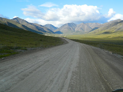
When oil was discovered in Prudhoe Bay in the late 60's, they needed a way to get it to market. The U.S. was right in the middle of a gas/oil crisis, so building a pipeline became the nation's priority. The 800 mile Trans-Alaska Pipeline was built in three years and the Haul Road was built in record time, just five months! It's only been since 1994 that the general public's been allowed to drive the road it's entire length. Now it's kind of a destination highway, meaning the road itself is the attraction, not how far you actually travel on it.
Having been made famous by the show Ice Road Truckers, we were surprised, and happy that we didn't encounter a lot more truck traffic than we did. However, we were stopped quite awhile waiting for this big rig to pass by.....
The truck & trailer rig was 105 feet long and it's cargo about 20 feet wide. The three big trucks traveling behind it are pusher trucks to help it get up the hills. Duane talked to the flagger who told him it has a permit for maximum 25 MPH. That's a slow 850 mile trip from Anchorage to the North Slope!
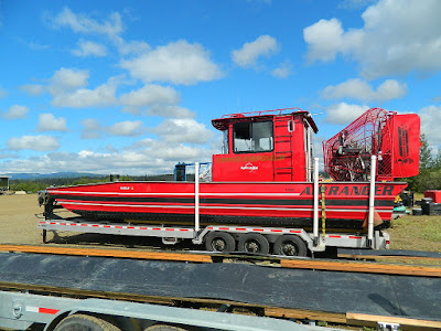
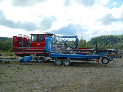
We were told at the visitor center that Alyeska Pipeline would be starting spill response exercises the next day and be sure to check out the airboats they'd be using. One is the largest one in the world. I'm sure you can tell which one!
The Yukon River is humongous!
Here's a section of the pipeline just before it crosses the Yukon River
The pipeline parallels the road, either above or below ground for the entire length of the road. It's the backdrop for a lot of the beautiful scenery and sometimes the star of the show. Our vantage point at the top of this particular hill provided us this interesting view.
The next stop on our travels was Finger Mountain. The panoramic views from this alpine tundra are magnificent. Granite slabs, called Tors jutting up across the landscape were created millions of years ago, when magma pushed up through the bedrock. It became hard granite as the magma cooled. Throughout time, erosion has washed away much of the smaller and softer rocks. These granite tors are what remain today. Maggie led the way to the most prominent tor in the area, Finger Rock.
Look close. Can you see Jean in the center of the tor?
Even though fireweed grows prolifically in the area, its unusual to see white fireweed...
Before long we reached the Arctic Circle. At this imaginary line that circles the globe the sun doesn't set for 24 hours on the summer solstice. From here north, the time the sun stays above the horizon gets progressively longer. This is great for accomplishing all your outdoor projects. However the opposite happens at winter solstice, when the sun never makes an appearance for one full day! At the spring and fall equinox there is exactly 12 hours of daylight at the Arctic Circle. Everyone driving the Dalton stops here to mark this special time in their lives with a photo. It's easy to find someone to take your picture. Unfortunately there were a couple of dogs running around and Maggie was being an idiot in the truck and wasn't allowed to get her picture taken with us.
We got a certificate to prove we crossed it.... cool huh?
We'd arrived at our target location. However, the weather was fabulous, the lack of mosquitoes was mind boggling and we were seeing too much incredible country to turn back now. We decided to continue on. 75 miles farther north as we crossed the middle fork of the Koyokuk River, we took a turnoff to the historic village of Wiseman. It was a bustling place when gold was discovered there in 1907, but now is a pretty sleepy little hamlet. We had thought of finding a cabin or B&B to rent for the night, but I guess they close up shop early in the evening. We drove around, and hardly saw a soul. Sort of feels like stepping back in time 100 years.
Fireweed lines the shore of the Koyokuk River...
Not far out of Wiseman we spotted this very skinny moose in a pond near the pipeline. She didn't seem at all concerned that we stopped to watch her eat. Gotta say, Maggie was the one to spot her. Duane was just taking a picture of another mountain!
Being in the land of the midnight sun allowed us to continue driving late into the evening and the lighting was beautiful. Large fireweed patches were breathtaking along the northern mountainsides, especially when the sun hit it. From our vantage point where we took this next picture, we watched the sunshine light up the land as the clouds were quickly moving overhead. It looked like someone was playing with a flashlight.
Before long, Sukakpak Mountain came into view. They say when the sun hits it just right, it glows. It sort of seems like a glowing rhinoceros trying to hide behind the the mountain in the foreground.
As we got closer the rhinoceros came out of hiding....
There were so many incredible sites to see along this journey and we were delighted we'd decided to continue on instead of turning back at Arctic Circle. Our new turn-around point on the highway would be the north side of Atigun Pass. After passing Sukakpak Mountain, the landscape began changing as we approached the Brooks Range. We had reached Atigun Pass and at this point we crossed the Continental Divide. Rivers north of here flow into the Bering Sea and rivers flowing south, flow into the Pacific Ocean. Atigun Pass was made famous by watching the Ice Road Truckers make their way through that pass in horrific conditions. Although we weren't in ice or snow, it didn't take much imagination to realize the expertise and experience the truckers need to make it safely through this section of the highway.
This was our view coming back over...
While driving toward Atigun Pass we kept our eyes open for a place we could spend the night. We couldn't have been happier than this sweet boondocking site along the Dietrich River, at the base of our now favorite rhinoceros, Sukakpak Mountain. The mountain looked totally different looking at it from this direction.
Even late at night the mountain across the river from us was in full sun. The sun eventually set at 12:33 in the morning (I had to look that up online) and rose again around 3:00am. However, the sky was quite light all night long and sometime about 2am when I looked, the pink clouds were still illuminated.
Had we known what great weather we were going to have and had brought more food along, we would have been tempted to stay along that river for another day. Reluctantly, we left the next morning to head south. We'd spent a night above the Arctic Circle and experienced a unique area of Alaska not visited by many people. We couldn't resist stopping again at Arctic Circle so Maggie could have her picture taken too. We're pretty certain she was happy about that.


Your experience reminded me of a sheep hunt Steve and I had in this same area. There were a lot of fires on the way that year since it was so hot and dry. It was still a beautiful place and a great time. Thanks for sharing your thoughts and pics. Happy trails. Jeff
ReplyDeleteJeff, There's still a lot of evidence of those fires and there was new fires up that way this summer too. Those large patches of fireweed spring up after those wildfires. Nature proving its still in control.
DeleteThis comment has been removed by a blog administrator.
ReplyDeleteLove reading your stories Jean. Thanks for describing the trips I'll never take. :)
ReplyDelete